Thessaloniki is the second largest city in Greece and the largest and most populated in the region Macedonia. It was built around the Termaj Bay and boasts a long history dating back to ancient times. It is home to many sights, and its protective attraction is White Tower, as well as several hotels and places to eat and drink. It is also an ideal base for exploring the northern part of Greece, especially if you have your own vehicle.
Where is it located? Thessaloniki? Distance from Thessaloniki from Athens is 303 km (straight line). Popular Halkidiki is located a few kilometers from the city, while Thassos the closest island destination (although they are not connected).
Thessaloniki has an international airport, as well as a port that plays a major role in trade and transport.
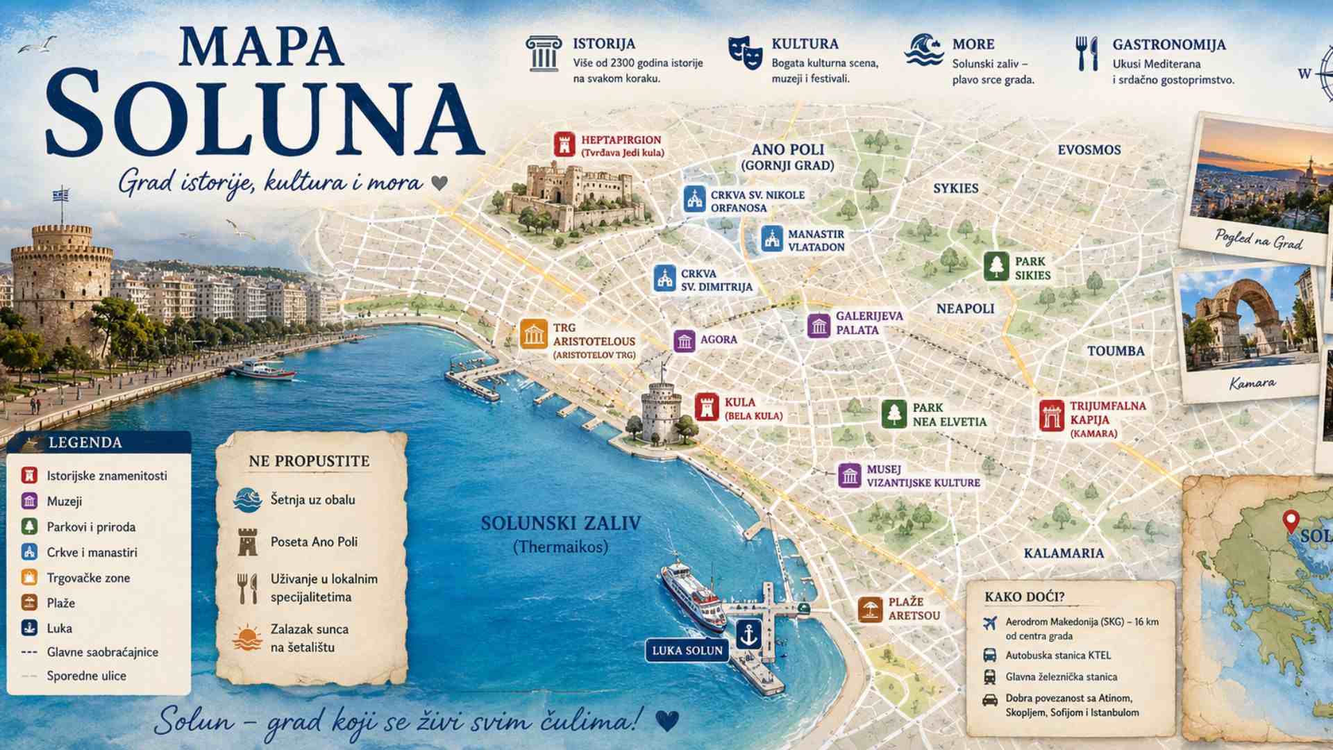
Interactive map of Thessaloniki
Landmarks, neighborhoods, beaches and arrival points are marked on the map. The map opens in the center of the city, and you will see the airport and beaches south of the city when you zoom out. Click on the dot for a short description and a link to our text.
Sights, neighborhoods and transportation in Thessaloniki
Landmarks
- White Tower – Symbol of the city on the coast, today a museum.
- Rotunda - Roman building from the 4th century, under the protection of UNESCO.
- Arch of Galerius - Roman triumphal arch with reliefs, on Egnatia.
- Church of Saint Demetrius - Church of the protector of the city, with a crypt.
- Church of Saint Sophia – Byzantine church from the 8th century.
- Panagia Halkeon – Byzantine red brick church from the 11th century.
- Roman Forum - Remains of the Roman square and vestments.
- Bay Hamam – The first Ottoman hammam in the city.
- Eat the Towers - A fortress with seven towers on top of Gornji Grad.
- Vlatadon Monastery – Monastery in Gornji Grad with a view of the bay.
- Archaeological Museum - A rich collection from ancient Macedonia.
- Byzantine Museum – Museum of Byzantine culture.
Neighborhoods and squares
- Aristotle Square - The main square, open to the sea.
- Ladadika – Bohemian quarter with taverns, near the port.
- Ano Poli – Upper town with old houses and ramparts.
- Navarino Square – Student Square near the remains of the Galerius Palace.
- Thessaloniki coast – The new coast for walking, from the White Tower to Kalamaria.
Nearby beaches
- Perea - A lively beach southeast of the city.
- Agia Triada – One of the most beautiful beaches in the bay.
- Nea Michaniona – A quiet place with a beach and fish taverns.
Airport, stations and port
- Thessaloniki Airport (SKG) - "Macedonia" International Airport.
- Macedonia Bus Station – The main intercity bus station.
- KTEL Halkidiki - Special bus stop for Halkidiki.
- Railway station – The main railway station and the beginning of the metro line.
- Port of Thessaloniki – The city port, next to the Ladadika quarter.
Most of the sights in the center are within walking distance, and the Upper Town is easier to reach by bus or taxi. More in the texts Thessaloniki attractions i Thessaloniki neighborhoods.
Distances from Thessaloniki Airport
The distances are calculated by road, and the driving time is approximate and without crowds. During rush hour and summer, expect significantly longer.
| Destination | Distance | Driving (approximate) |
|---|---|---|
| KTEL Halkidiki | 8 km | 10 minutes |
| Perea | 11 km | 15 minutes |
| Agia Triada | 15 km | 20 minutes |
| White Tower | 17 km | 20 minutes |
| Aristotle Square | 17 km | 25 minutes |
| Ano Poli | 19 km | 20 minutes |
| Railway station | 19 km | 25 minutes |
| Nea Michaniona | 20 km | 25 minutes |
| Macedonia Bus Station | 22 km | 30 minutes |
Where to stay in Thessaloniki
- Center around Aristotle Square and Ladadika – the best choice for a first visit, with sights, restaurants and the coast within walking distance.
- The surroundings of the White Tower and the new coast - pleasant for walks by the sea, near the museum.
- Calamari - a quieter part of the city, closer to the airport and the beaches south of Thessaloniki.
- You can compare offers for all parts of the city at Booking.
Frequently asked questions
How far is the airport from the center of Thessaloniki?
The distance to Aristotle Square is in the table above. Bus X1 runs from the airport to the center and the main bus station.
Does Thessaloniki have a metro?
There is, from the end of 2024. The line connects the railway station, the center and the eastern parts of the city.
Where to swim near Thessaloniki?
On the beaches south of the city, in Perea, Agia Triada and Nea Mihanioni, or on Halkidiki. More in the text Map of Halkidiki.
How to get to Thessaloniki